
Projects
Building a portfolio of high-quality gold exploration opportunities across North America
Eagle Lake Gold Project
District-scale system. Proven belt. Significant upside.
World-Class Geology
Located in one of Canada’s prospective greenstone belts
High-Grade Gold
Historical surface samples of up to 204 g/t Au
1,986 Hectares
Large, highly prospective land package
Underexplored
Only 26 shallow historic drill holes completed
AI-Driven Exploration
Machine learning-assisted target generation with MINML
Clear Path to Discovery
Systematic exploration advancing priority targets
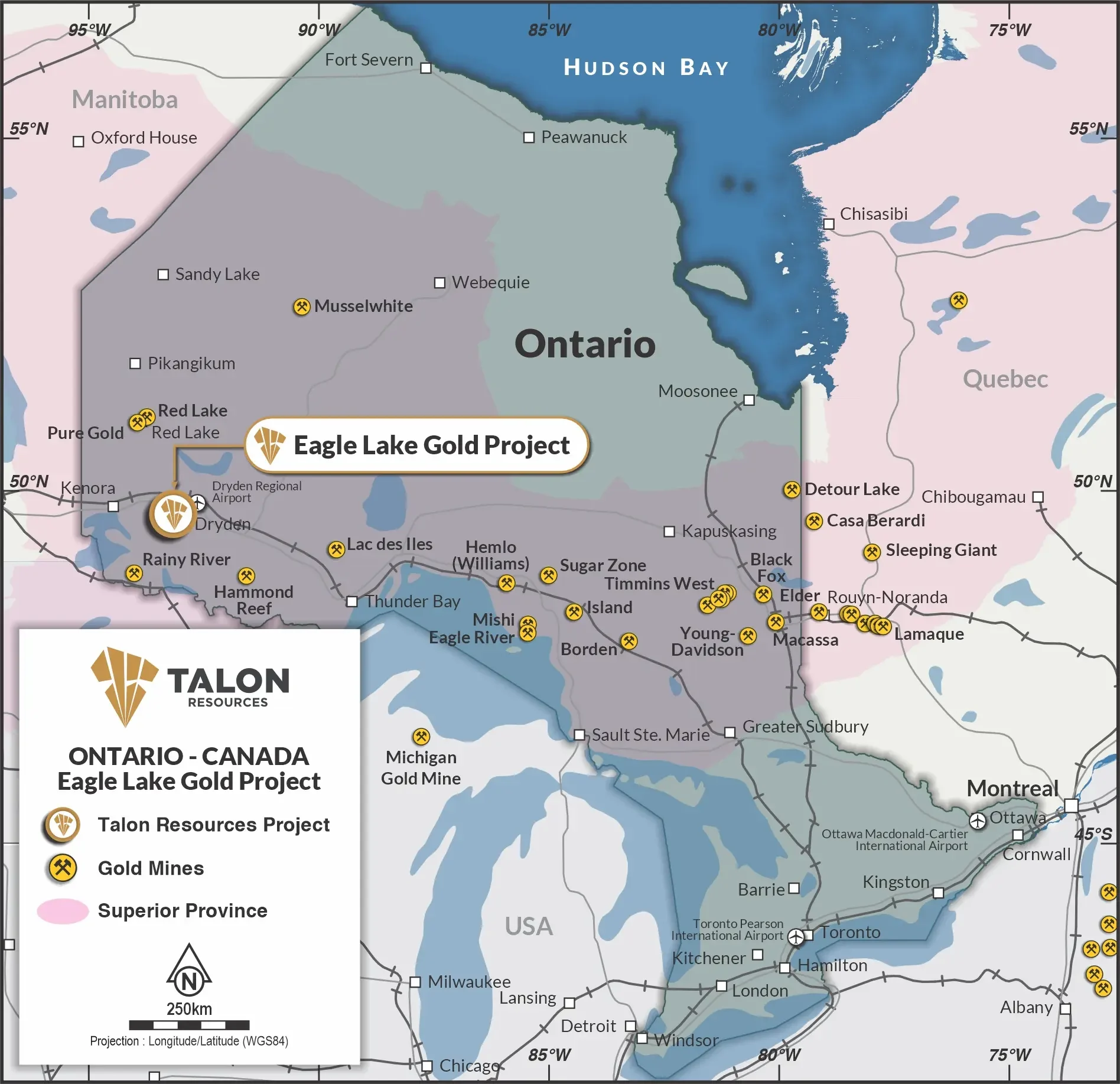
Regional Setting
The Eagle Lake property lies on the south shore of Eagle Lake, approximately 30km southeast of Dryden, Ontario. Located in the Kenora Mining Division, the property is within the Wabigoon Subprovince of the Archean Superior Province of the Canadian Shield, one of the world’s most prolific and well-understood gold-bearing granite-greenstone terranes.
The Wabigoon Subprovince hosts numerous past-producing gold mines and active development projects, in some cases backed by gold majors and major funds, associated with shear-hosted quartz-carbonate vein systems – the same mineralisation model as Eagle Lake.
The geological framework is analogous to other Superior Province greenstone belts that have delivered multi-million-ounce discoveries: Musselwhite (Pan American Silver, ~3.7Moz Au), Hammond Reef (Agnico Eagle, ~8Moz Au resource), and Rainy River (First Mining Gold, ~5Moz Au) all sit within the broader Superior Province terrane context.
Ontario remains one of the world’s top-ranked mining jurisdictions (Fraser Institute consistently top-5 globally) – permitting risk is manageable, infrastructure is established, and capital markets understand the address.
The combination of an Archean greenstone belt setting, a structurally controlled orogenic gold model, and district-scale untested land package provides a credible discovery pathway consistent with regional peers in this emerging gold exploration hot-spot.
Exploration History
Multiple operators across six decades have consistently returned multi-gram and bonanza-grade values across several structurally distinct zones. This is not a single occurrence – it is a district-scale mineralised system that has never been systematically drilled with modern methods.
Historical data reports grab sample grades up to 204 g/t Au (Parker Shear). A 2025 field campaign of grab, chip and channel samples includes several between 25 g/t Au and 75.7 g/t Au.
26 shallow holes were drilled between 1951-1985 with the following significant results:
| DDH | From (m) | To (m) | Interval (m) | Au (g/t) |
| R-82-3 | 64.00 | 67.06 | 3.05 | 1.95 |
| R-83-6 | 53.34 | 59.44 | 6.10 | 1.64 |
| R-83-10 | 5.24 | 7.62 | 2.38 | 1.20 |
| 24.38 | 30.48 | 6.09 | 1.70 | |
| 35.05 | 38.10 | 3.05 | 1.13 | |
| 42.67 | 45.72 | 3.05 | 2.54 | |
| 99.01 | 102.11 | 3.05 | 3.94 | |
| R-83-11 | 17.98 | 18.75 | 0.76 | 1.95 |
| 101.50 | 103.02 | 1.52 | 2.78 | |
| R-85-12 | 18.29 | 19.51 | 1.22 | 2.74 |
| 23.16 | 24.23 | 1.07 | 8.23 | |
| 27.43 | 30.48 | 3.05 | 2.05 | |
| 36.58 | 39.62 | 3.05 | 2.05 | |
| R-85-13 | 51.82 | 54.86 | 3.05 | 7.54 |
| R-85-16 | 9.14 | 12.19 | 3.05 | 2.05 |
Key Target Areas
Fornieri Bay Occurrence – Follow-Up Drilling
Most extensively tested area historically; 26 historical holes were all shallow; quartz veining with up to 10% disseminated sulphides; Au-Cu geochemistry; new zones identified along strike in 2013; 2025 grab samples returned up to 75.7 g/t Au – significant unexplored extensions.
Parker Shear – Emerging Target
Up to 204 g/t Au, including 51.30, 39.80 and 36.90, from channel sampling – potential extension to Fornieri Bay.
Bjorkman Shear Zone – Upside Potential for Strike Extension
SSE–NNW trending shear with intense deformation; strong alteration halo and confirmed gold at surface; humus anomaly converging on zone; open along strike and at depth – never properly drilled.

